 Adobe XD
 Adobe Photoshop
 Adobe Illustrator
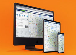
I had the opportunity at Castle Rock to work on various Department of Transportation-related products. It was a pleasure to redesign a Traveler Information System known internally as OneWeb.
OneWeb provides real-time traffic and weather conditions, road construction and closures, and other travel-related information to the general public, helping drivers plan their trips and navigate the state’s highways and roads more efficiently.
Providing Results
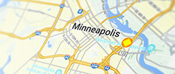
Have you ever wanted to just type into the search bar what you are thinking? like “Show me cameras along I-70?” and get the desired results?
Searching for information as a user can be challenging. That's why I designed a robust search system based on a natural language processing algorithm. This system enables users not only to input roads or points of interest but also predicts their input and offers additional actions, such as enabling layers.
Getting Detailed
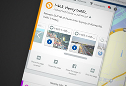
How can a Department of Transportation inform the general public of impactful incidents?
Users can hover or click events to get detailed information about a given event or incident. I designed the feature to allow the results to display any additional events happening up and down the roadways and nearby cameras to give the user a better picture of what's going on.
Traffic Cameras
Have you ever wondered what the road conditions look like during a storm? Or, how a new construction project is going to affect your commute?
I wanted users to quickly access hundreds of live traffic cameras across the state. Users can hover over or click on the camera icons on the map to view live video feeds of traffic conditions in real-time.
Great job on updating traffic and links!!!!!!!! Love the bigger camera views
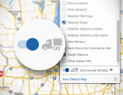
Customizing Layers
Motorists want to know about unplanned traffic events. Commercial vehicle operators might need to know where the nearest rest area or weigh station is located, or if there is a restriction that they will need to avoid.
I designed OneWeb with the flexibility for users to see only the information that is of interest to them. I incorporated tools which make it super simple to enable frequently-used layers with a single click.